Sonoma County Breeding Bird Atlas Maps
The species maps from both Sonoma County Breeding Bird Atlases (BBA) are now complete! A few examples are shown below, plus links to both of the map files, available for download. Credits and copyright information are located at the bottom of this page.1
To view or download the maps, plus how-to instructions, click BBA maps or scroll to the bottom of this page.
Canada Goose
Partly due to the increased hours of surveying during the second Atlas, many bird species were confirmed in more blocks, compared to the first Atlas. The species with the greatest increase was the Canada Goose. There may be other reasons for the increase in the number of blocks they were found nesting in, such as the construction of more golf courses with ponds, and other habitats that they prefer.
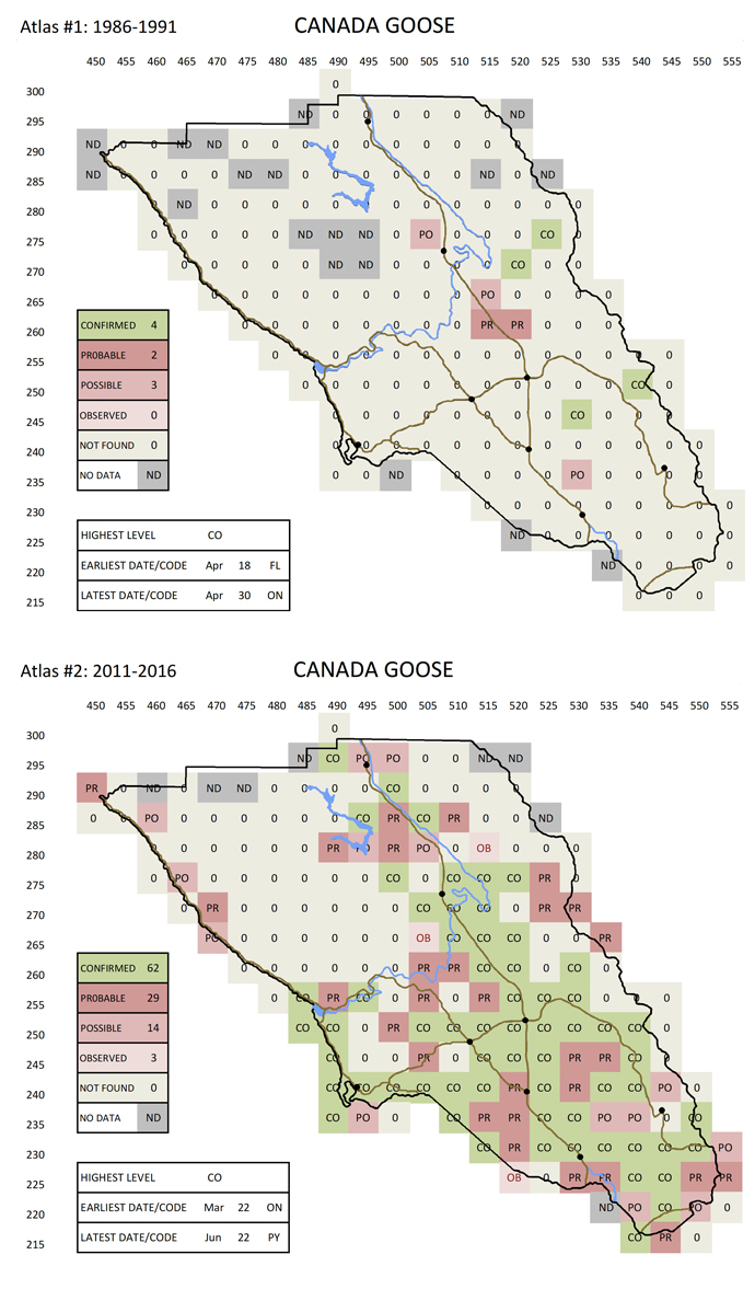
Canada Goose BBA results
Cinnamon Teal
Some species, even with the increased hours of surveying, were confirmed in fewer blocks on the second Atlas. This may be due to breeding habitat loss, especially from the drought, human population increase, and other factors.
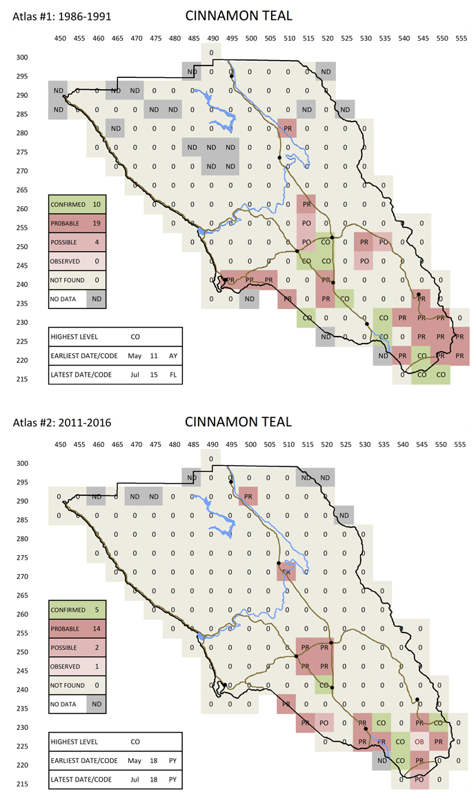
Cinnamon Teal BBA results
Eurasian Collared-Dove
Other species have spread into Sonoma County since the first Atlas was completed. One of these is the Eurasian Collared-Dove, which has worked its way across the United States starting in the late 20th century, only reaching Sonoma County by about 2008. Another species that is new is the Great-tailed Grackle, which has expanded its range north from south-central California, probably due to the warmer temperatures associated with climate change.
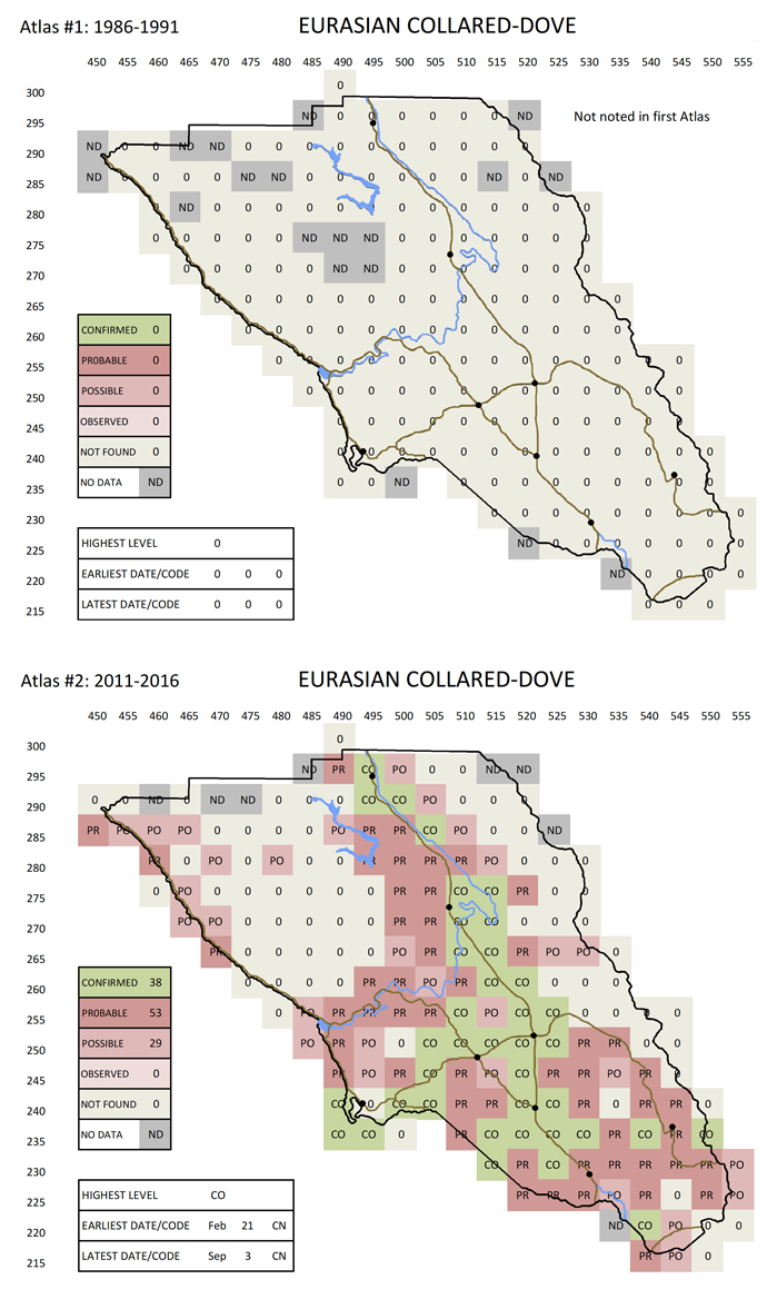
Eurasian Collared-Dove BBA results
First BBA maps
Viewing Instructions
In order to view the maps, you may view them in your browser, or download both pdf files, and then open them up on your device (larger screens recommended).
To view them in your browser, click on the links below to open both pdf files. If your browser supports tabbed browsing, resize your browser window so that it only takes up half of your screen, then drag one of the tabs so that it is in a separate window, next to the first window. Alternate between Atlas #1 and Atlas #2 to scroll to the desired species maps (species page numbers are the same for both Atlases).
To view them in Acrobat Reader, you will need to download the free application if you do not already have it on your device. Then download and open both Atlas pdf files. Go to the Window menu, click on Tile, then select Vertical. Both map files should be visible side-by-side. You may need to resize the windows so they will fit on your screen. Alternate between Atlas #1 and Atlas #2 to scroll to the desired species maps (species page numbers are the same for both Atlases).
Click ATLAS #1 for a pdf copy of the FIRST BBA Atlas (1986-1991).
Second BBA maps
Click ATLAS #2 for a pdf copy of the SECOND BBA Atlas (2011-2016).
1 These breeding bird atlas maps were created based on field data collected from 1986 through 1991, and from 2011 through 2016. The Excel spreadsheet data has been organized to create the species maps, early and late dates, and county overlay by David Leland and Gordon Beebe, volunteers with Madrone Audubon Society, copyright 2018.
Find us on Facebook 
It's Nesting Season: trim trees in the Fall!.
Amazon Smile: donate to Madrone when you shop
Birding Quiz - test your skills.
Leaves Newsletter
Carved Bird Pins
In the 1970s, member Tom Olds hand-carved bird pins and sold them to raise money for Madrone Audubon. More